Risk Assessment Protocol*
This protocol has been deprecated and is no longer supported in the protocol library.
Overview
The Risk Assessment Protocol is designed to identify and evaluate potential restoration risks to infrastructure and assess recovery potential in valley bottoms. The protocol consists of four key components:
- Stream Assessment: This component evaluates LTPBR opportunities within streams.
- Land Use Assessment: This step analyzes current and historical land use to gauge the recovery potential of restoration.
- Infrastructure Risk Assessment: This focuses on identifying and assessing risks to infrastructure typically found in valley bottoms, such as buildings, roads, bridges, canals, and diversions.
- Property Assessment: This final component assesses input and support for LTPBR from local property owners, managers, and stakeholders.
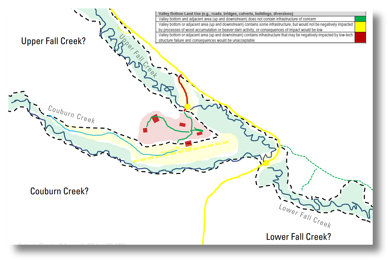 Example of risk assessment evaluation within the valley bottom after Tier 1 geomorphic units have been identified and mapped.
Protocol Summary
| Attribute | Value |
|---|---|
| Name | Risk Assessment Protocol |
| Status | Deprecated Grade |
| Version | 1.0 |
| XML URL | https://github.com/Riverscapes/RiverscapesXML/blob/master/QRiS/protocols/risk_assessment_protocol.xml |
| Citation | NA |
| Author | Zach Burgert |
Layers & Metrics
| Attribute | Type | Description |
|---|---|---|
| Stream Assessment | Linestring | evaluate LTPBR opportunity by assessing stream order, bank material, bed material, riparian vegetation health, and flood risk. |
| Land Use Assessment | Polygon | evaluate current and estimated historic land use of the valley bottom, as well as the departure of current riparian vegetation from historical conditions. |
| Infrastructure Risk Assessment | Point, Linestring, and Polygon | assign a categorical risk value to identified infrastructure within the valley bottom based on its location to the stream and other relevant factors, such as flood risk. |
| Property Assessment | Point | evaluate the willingness of the landowner or manager to permit LTPBR processes on their property, and gauge the general attitudes of local property owners and stakeholders towards LTPBR. |
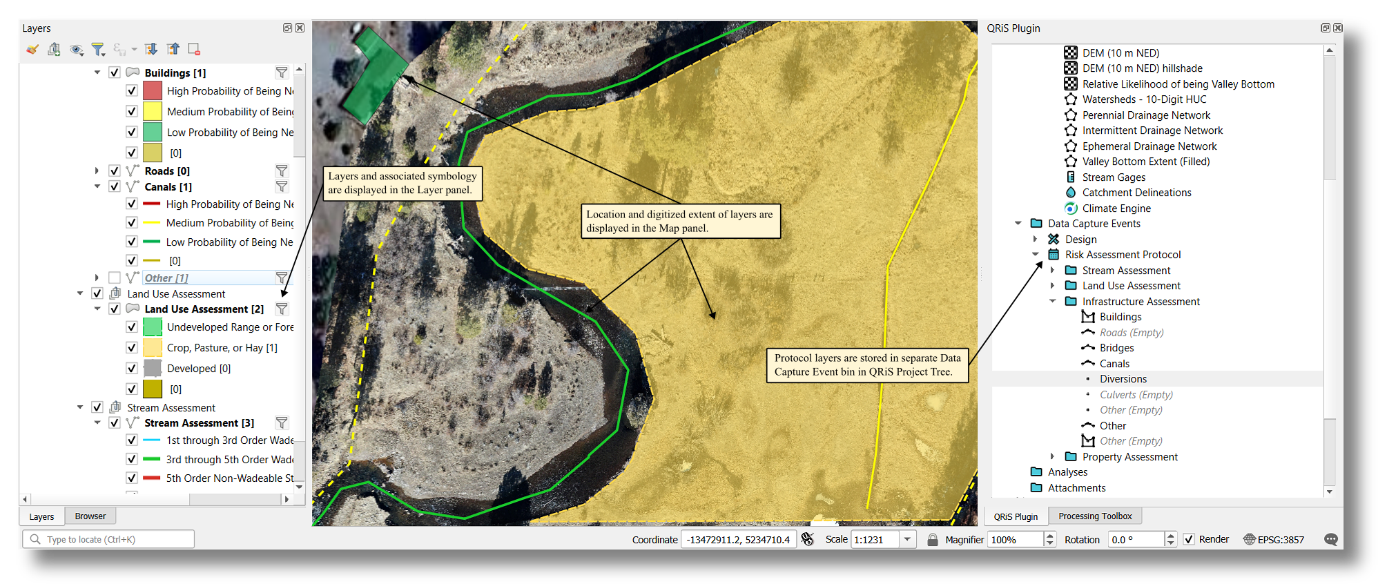 Example of risk assessment protocol digitized in the valley bottom. Digitized layer extents and symbology are stored in the QRiS geopackage and can be displayed in any QGIS (.qgz) project.
Video Demonstartion
Layer Attributes
- Stream Assessment
- Land Use Assessment
- Infrastructre Risk Assessment
- Property Assessment
Layers: Stream Assessment
| Field | Description | Values |
|---|---|---|
| Stream Order Wadeability | assessment of stream size for LTPBR | |
| Bank Material | assessment of bank erodibility by LTPBR structures | |
| Bed Material | assessment of bed material for potential habitat | |
| Riparian Vegetation | assessment of riparian vegetation for habitat or recovery potential | |
| Flood Risk | assessment of stream for potential flood risks to LTPBR structures | |
| Opportunity Rating | numeric value for LTPBR opportunity of given stream on scale from 0 (least ideal stream locations for LTPBR) to 5 (most ideal stream locations for LTPBR) | NA |
Layers: Land Use Assessment
| Field | Description | Values |
|---|---|---|
| Current Land Use | contemporary land use of the valley bottom | |
| Historic Land Use | estimated historic land use of the valley bottom | |
| Estimated Riparian Vegetation Departure | assessment of riparian vegetation departure from historic conditions as result of changing land use |
Layers: Buildings, Roads, Bridges, Canals, Diversions, Culverts, Utility Lines, and Other
| Field | Description | Values |
|---|---|---|
| Location | location within valley bottom | |
| Flood Risk | potential risk of contemporary flooding to infrastructure | |
| LTPBR Risk | potential risk of infrastructure being impacted by LTPBR based on location and flood risk |
Additional Fields for Utility Lines
| Fields | Description | Values |
|---|---|---|
| Utility Location | location of utility line | |
| Utility Type | type of utility line |
Layer: Property Assessment
| Field | Description | Values |
|---|---|---|
| Channel and Floodplain Adjustments in Valley Bottom | willingness of landowner/manager to allow stream and floodplain adjustments in valley bottom | |
| Wood Accumulation and Beaver Activity in Valley Bottom | willingness of landowner/manager to allow wood accumulation and/or beaver activity in valley bottom | |
| Adaptive Management | willingness of landowner/manager to participate in adaptive management |
Layer: Adjacent Landowner Assessment
| Field | Description | Values |
|---|---|---|
| Support for LTPBR | local support of landowners towards LTPBR actions |
Resources
Bennett et al. 2019
Chapter 3 – Planning for Low-Tech Process-Based Restoration from LTPBR Design Manual