Stream Gage Explorer
The Stream Gage Explorer allows you to add stream gage data to your QRiS project. Stream gage data is provided by the USGS and is available for download from the USGS National Water Information System (NWIS) website.

Accessing the Stream Gage Explorer
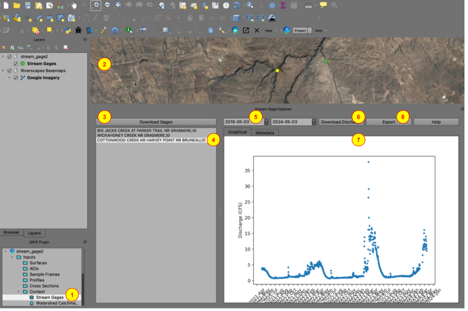
The Stream Gage Explorer is accessed from the Context Node in the Project Tree. To access the Stream Gage Explorer, expand the Context Node in the Project Tree and right-click on the Stream Gages node, then select Explore Stream Gages (1).
Downloading Stream Gage Data
-
First zoom in to the area of interest in the map view (2). This sets the extent of the stream gage sites that will be downloaded.
-
Click the
Download Gagesbutton (3). This will download the list of stream gages from the USGS NWIS website for the current map extent and add them to the map. -
From the list of stream gage sites, select the stream gage site that you would like to add to the project (4). The map will zoom to, and select, the stream gage site from the Stream Gages layer.
-
Set the start and end dates for the stream gage data that you would like to download (5).
-
Click the
Download Dischargebutton to download the stream gage data for the selected site and date range (6). The discharge data will display in the graphical tab (7).
The data is automatically saved to the project file. To view previously downloaded stream gage data, simply click on the stream gage from the list of stream gage sites and set the desired date range.
Exporting Stream Gage Data
To export the stream gage data to a CSV file for an individual stream gage, make sure it is selected in the list of stream gage sites, then click the Export button (8). Select the location where you would like to save the CSV file and click Save.
Stream Gage Metadata
To view the metadata for a stream gage, select the stream gage from the list of stream gage sites. The metadata will display in the metadata tab.